
meacham's
HISTORY
OF CHRISTIAN COUNTY KENTUCKY
by
charles
m. meacham
1930
CHAPTER II
BLAZING THE WAY
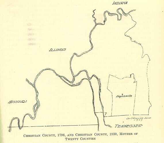
The Pioneer Period and the Settlement in What Became Christian County;
The New County; Its Vast Extent; Its Rivers and Topography.
No Indians lived in this part of Kentucky, but there were many Indian graves, and relics were found everywhere, such as tomahawk flints, spear-heads, arrow-heads and the like. No real attempts were made to settle the state this far west until about 1782 although there were posts on the Mississippi and Ohio rivers. Immigration had been pouring into the new state, then a county of Virginia, for ten years. Boone, Stewart, Kenton and other pioneers had come through Cumberland Gap on down the Ohio river and battled with the roving bands of Indians who came from the South and North to use the Happy Hunting Grounds that abounded in game, big and little. The first settlers had stopped in the eastern portion, where there were great forests and game was plentiful. They were satisfied to build their cabins in this good land. A little later others came who pushed westward and found a better land, a land of surpassing beauty, with grazing grounds filled with vast herds of buffalo, elk and deer. Here they built forts, staked out claims and decided to remain. The Mississippi Valley at that time was claimed by Spain as well as the Indians and stretching from the Bluegrass to the Mississippi was a vast extent of unknown wilderness. The early settlers little dreamed that if eastern Kentucky was good, and Central Kentucky was better, there was yet another part of Kentucky that was best of all. That land became Christian County.
Prior to 1786, Kentucky was still a district attached to the colony of Virginia. The district or county, at that time having about 30,000 population, had been seeking separation in a series of constitutional conventions that began in 1784. These conventions continued until finally in 1789 terms of separation were agreed upon. The new colony at once started a movement to enter the newly organized government, whose independence had been won in the war of the Revolution. After a delay of three years more this was brought about, and on June 1, 1792, Kentucky was admitted as one of the first two new states, after the organization of the thirteen original colonies into the United States of America.
From 1763 until the peace of 1783, all of the country west of the Tennessee river was a part of an Indian reservation proclaimed by King
George III in making peace with the Indians, who frequented Kentucky as1 hunting ground. Consequently, that part of the new State and in fact all of the western portion had not been opened to settlement while it was British territory and was twenty years behind the Eastern and Central parts. The county of Nelson therefore embraced this frontier, extending to the Mississippi river. In 1786, Madison County was created and soon other counties followed in the sections of the district where population was increasing as a tide of immigration came over the mountains and down the Ohio river. In 1792, when Statehood began, the big county of Nelson was divided and Logan County was created from the western part. Four years later Logan was in turn divided, Logan retaining the settled portion and Christian County was born and fell heir to the frontier. It included all of the territory west of Green river and west of a line extending southward from Green river to the Tennessee line. along what is now the eastern line of Todd County. The new county thus extended one hundred and fifty miles westward, including a princely domain of about 7,500 square miles, an area larger than Connecticut, Delaware and Rhode Island, three of the original states, combined. Its territory was about the size of New Jersey and was rich in diversified resources, some of which are still hidden and undeveloped. It did not take the waiting pioneers long to realize that here was a veritable Paradise awaiting settlement. The new state added to the union was lying in the center of its map, like a luscious country ham. Its fat end resting upon the Cumberland range was first seized upon for its beautiful mountains, its forests filled with game, and its nearness to the mother colonies of Virginia and North Carolina. Then further along the real meat of the ham appeared when the bluegrass was found with its streaks of lean and fat, each slice food for the gods. The new owners were slow to realize that the choicest meat was yet in store. The hock of the ham and all of the sweetest morsels found nearest the bone were reserved for those who could be satisfied only with the best. Christian County set about the business of organization without delay as a caravan of ox-teams brought in settlers from the east.
It is not the purpose of this history to attempt to cover the ground
that has been gone over by the many histories that have been written of
Kentucky, recording in detail the dangers, the heroism and the perseverance
of that noble band of pioneers who carved the new state out of the wilderness
and brought it into the Union as the first-born of thirty-five commonwealths
that have been added to the original thirteen. These early settlers were,
many of them, soldiers who had helped to achieve independence. They came
from the eastern states, blazing the way for civilization, driving out
the Indians, many of them dying in the attempt, and building their homes
in the wilderness.
The eastern portion of the state was occupied first, then the Bluegrass section and finally the western portion, originally all in Christian County. The experiences of the settlers were the same as their brothers had undergone in the other sections. The outposts were pushed further and further into the hunting grounds that the Indians continued to claim, until finally all of the territory between the rivers and beyond to the Mississippi. was gradually settled and cut off from the parent county, and in the end a score of new counties formed. For many decades Hopkinsville, the county seat, was the largest town in Western Kentucky. This history will, therefore, deal with the part Christian County has played in the his-. tory of Kentucky. A century of development has brought out the fact. that this favored section was the best part of the state. Its mighty rivers,. its primeval forests, its broad plains, its rolling topography, here a fertile valley and there a hill filled with some valuable mineral, made it a marvelous country of varied and boundless resources. The Christian County of today lies in the two formations that divide Western Kentucky. The northern half is underlaid with carboniferous limestone and sandstone on the hills, the extreme north extending into one of the greatest coal fields in the state. The southern half of the county is of sub-carboniferous limestone formation, with a fertile soil and numerous springs and small streams. Two branches of Little River rise in the north and flow southward and come together a few miles south of Hopkinsville and the larger stream makes its way to the Cumberland River. Another branch of the same river flows through the western part of the county; it is known as Sinking Fork, because at one place the stream sinks and flows underground for several miles and rising continues its course. Hopkinsville is situated, or was originally laid out, on the east bank of the west branch of Little River, but the river now flows through the city. The city has likewise been extended a mile or more eastward, to the east branch of the river. These streams are separated by a ridge that rises to an elevation of five hundred feet above sea level, in some places. The city has an abundant water supply, is well located and is a picturesque and beautiful little city of ten thousand population.
Besides the streams already mentioned, there are three other rivers in the county as large as Little River. One of these forms the northeastern boundary and is called Pond River, because there are many wide places in it resembling ponds. This river flows northward into Green River. In the northwestern portion of the county the Tradewater River flows into the Ohio. In the extreme southeastern part, a small part of Red River is in the county, a tributary of the Cumberland. In this section was located the very earliest settlement in the county as finally bounded. Of this more will be said.
There are some natural curiosities in the county that are worthy of especial mention.
SOME NATURAL CURIOSITIES
PILOT ROCK
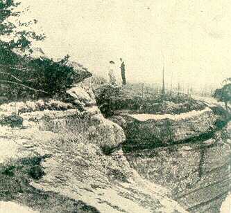
One of the natural curiosities of Kentucky, is located in the eastern part of the county, near the Todd County line. It is referred to in Collins History of Kentucky, but not accurately described. Its summit is not level and its area is not as much as half an acre, but it is an elevated crag that towers high above the surrounding landscape. It is approached by an unimproved country road through the woods and for this reason is not accessible at all times. However, the road program of the county provided for in 1929 is expected to improve the road leading to it.
From out of a wooded plain, the rock rises high above the tree tops surrounding it. The road by which it is approached, after a gentle ascent to higher ground in the woods, suddenly comes within the shadow of the great pile of stone rising a hundred feet or more. On the side first seen the rock seems solid; passing around it on the east, crevices and ledge formations appear. The ground about the base of the rock is a steep incline. On one side we find a rugged pathway by which its summit may be reached and after a toilsome climb, clinging to the ledges and shrubbery on its side, the almost flat, but irregular, top is gained. From this top one looks down on forest trees that reach only half way to where he stands. There is still a higher part than the first broad landing. Climbing over rugged rocks, the very pinnacle is finally reached from which the view is magnificent. The elevation including the hill upon which it stands, a silent sentinel of the passing centuries, is 200 feet above the wooded landscape and one can almost imagine that he can see the spires of Hopkinsville, thirteen miles away. The towering Jefferson Davis shaft, 351 feet high, is easily discernible several miles southward. The soul of the spectator is filled with the grandeur of the scene. Tradition says the Indians in the old days used the mighty rock as a camping place in their hunt for game and from its top viewed the landscape for miles around. In the crannies and crevices of the rock are found a variety of wild ferns, flowers and shrubbery. Contrary to expectation, the rocks top is not a perfect flat and even surface. It is rough and uneven. There is no place larger than fifteen feet square that can be used for dancing or for dining in the skies. There is, however, a small, flat rock, as large as an ordinary table, that has often been used by picnic parties, with other boulders supplying seats around it. Eighty years ago a work of fiction in which the Pilot Rock played a part described a cave in the rock which was purely imaginary. Aside from its rugged exterior, it is a solid boulder, thrown up by some prehistoric convulsion of nature, unlike any other feature of the country around it. There are caves in that part of the country, but not under the rock itself.
Near the city of Hopkinsville are two caves important enough to have
been explored. One a mile to the east is known as Flemings Cave. Its entrance
is a deep sinkhole and it can be penetrated for hundreds of yards. The
other known as Campbells Cave is about the same distance northeast of
the city. Its entrance is on a steep hillside under a great shelving rock,
making a chamber fifty feet deep and one hundred feet wide, from which
two passages branch in opposite directions that have been explored for
considerable distances. It is the belief that there is an underground passage
between these caves, too small for explorers to enter. Both of them have
been used for pleasure resorts, as springs of cool water are near them.
Dances were often held in Campbells Cave and in a pavilion near Flemings
Cave.
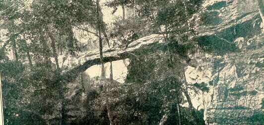
NATURAL BRIDGE
In the extreme northern part of the county is a natural bridge, also described by Collins. It is a great rock spanning a dry ravine through which a stream sometimes flows. It, too, was somewhat exaggerated. The bridge is about twenty or twenty-five feet long, but is not wide enough for a roadway. It is still concealed in a forest not far from a road through the hills.
A SINKING RIVER
One of the real curiosities of the county if the Sinking Fork of Little River, This stream, the most westerly of the three forks of Little River, rises in the northern hills and flows in a southwestern direction and suddenly disappears in a great sink hole. After flowing a considerable distance under ground it again emerges and continues its course to a junction with Little River in Trigg county, near where it empties into the Cumberland River.
SWALLOW SPRING
Four or five miles south of Hopkinsville on the Palmyra road there is an ordinary looking sink hole in a farm on the road. It is in a large valley field. At intervals, sometimes several years apart, this sink hole becomes a boiling spring that fills the whole valley with a lake of several acres that sometimes remains for months, but eventually subsides and disappears entirely. In one season after the waters had fallen until they only filled the sink hole, quantities of fish were taken out of it. Where they came from still remains a mystery. The Swallow Spring for many years caused trouble by flooding the highway during these overflows and many thousands of dollars were spent before the trouble was settled by the construction of a raised road higher than any overflow, several hundred yards across the valley.
MINERAL WELL
The Church Hill Mineral Well is located on an eminence five and one-half miles southwest of Hopkinsyule on Cockes Mill Road, and one mile northeast of the village of Church Hill. It is an exceedingly healthy community, on the highest point in the vicinity, and surrounded on all sides by a section of fine farming lands.
The well was bored in 1897, and is 105 feet deep, the first thirty feet being through clay; the remainder through solid limestone. A very strong stream of mineral water was found at this depth and the water at once rose to a depth of sixty feet in the well, and has since so remained.
The medicinal qualities of the water were soon appreciated by friends and neighbors, and the water was distributed free of charge to all who cared for it. Many people were greatly benefited by its use.
In 1906 a specimen from the well was sent to the Experiment Station of Agriculture at Lexington, and an analysis procured, which showed the water to be of some medical value. In the early summer of 1913, and at the urgent request of many who had continued the usage of the water all along, another analysis was procured, this time showing the water to contain very decided medicinal properties, after which the same was placed on the market. The result of this latter analysis showed the water to be strongly impregnated with calcium sulphate, magnesium sulphate, sodium sulphate, iron sulphate and traces of sodium chloride, potassium and lithium. Immediate sale was found for the water in Hopkinsville and surrounding sections of the country, and by each and all it was pronounced of great value to them.
Since July, 1913, many thousand gallons have been sold in and around
Hopkinsville. Quite a quantity has been shipped to various points, in all,
having embraced seventeen states.
The well is owned by Luther H. Smithson, Route 3, Hopkinsville, Ky.
THE GEOLOGICAL FORMATIONS.
There are unmistakable indications of prehistorical occupancy of Christian County by mound builders and steps have been taken to have excavations made by scientists connected with the State Historical Society. The two geological formations of sandstone and limestone referred to as dividing the county come together in Belmont Heights, the ridge separating the two rivers in the city. Some beautiful residences veneered with sandstone taken from their basements are on Seventh street, while the First Baptist Church and other imposing structures were built of limestone taken from the same hill a few hundred yards to the south, on Ninth Street.
The northern end of the county was first settled, many Revolutionary soldiers being given land grants in the new county. A commission was appointed to locate the county seat, and after several sites were visited and considered, the seat of government was located between the two forks of Little River; a few miles above where they come together, and Hopkinsville was laid out in 1797, and formally incorporated two years later. The little town was built around a never-failing spring of pure water that rose under a ledge of limestone and ran into the river. The land for public buildings was donated by Bartholomew T. Wood, five acres along the west fork of Little River. The town was first called Elizabeth, just why is not a matter of record, but in 1804 the name was changed to avoid conflict with another town of the same name in Hardin County, and the future city was called Hopkinsville, in honor of Gen. Samuel Hopkins, who was afterwards still further honored by having one of the twenty counties formed from Christians original territory named for him. The county as laid off was bounded on the east by Green River and in a line extending southward to the state line. Its western boundary was the mighty Father of Waters, the navigation of which played so important a part in the early history of the country. On the north the Ohio River gave it another river boundary. Flowing into it from the south and in the parallel course northward into the Ohio were two other great rivers, the Tennessee and Cumberland, each with numerous tributaries. These rivers at one place are only a few miles apart and for eighty years the primeval forests between the rivers remained a wild and unsettled country abounding in large game. There were hundreds of springs bubbling up from the earth, the fertile valleys all over the county were heavily timbered, the hills were covered with cedars and other evergreens, and the broad plains called barrens were fragrant with penny-royal, an aromatic weed indigenous to the soil and not found elsewhere in the state. Here and there were salt licks and beds of coal, iron and other minerals that in time became a source of great wealth, and these resources are still only partially developed. The settlers found a land to their own hearts delight. The best of Kentucky was at last open to settlement.
Christian County was quickly settled by the best pioneer stock the country afforded, Virginia and North Carolina contributing most of them. In the present bounds of the county the names of about forty Revolutionary soldiers have been preserved, but when it is remeffibered that Christian County of 1796 is now divided into twenty-one counties, it will be realized that there were hundreds of the valiant patriots. They were given land grants in the new county of fabulous dreams.
In a short time the influx of population called for smaller units and new counties were formed. This process continued from 1798, when Henderson, Livingston and Muhlenberg Counties were cut off, until Ballard, one of the daughter counties, was divided eighty years later and Carlisle was created. The twenty counties that sprang from the mother county have an aggregate area of nearly seven thousand square miles. About seven hundred and eighty square miles remained, making Christian second only to Pike County in its present area. Listed alphabetically Christian Countys daughters are:
Ballard, Calloway, Caldwell, Carlisle, Crittenden, Fulton, Graves, Henderson, Hickman, Hopkins, Livingston, Lyon, Marshall, Muhlenberg (in part), McCracken, McLean (in part), Todd, Trigg, Union and Webster.
The last counties cut from its remaining territory were its neighbors
Todd and Trigg, though there were many subdivisions of the larger counties
first created. Todd County, formed in 1819, was named in honor of Col.
John Todd, and Trigg, formed in 1820, was named for Col. Stephen Trigg.
Both of these soldiers fell in the battle at Blue Licks. Col. Trigg married
a sister of Col. William Christian. Jefferson Davis, president of the Confederate
states from 1861 to 1865, was born at the village of Fairview June 3, 1808,
ten years before the Davis homestead was put into Todd County by afew feet,
theline running through the Davis farm. The Bethel
Baptist Church is now located upon the site of the home and the replica
of the house now stands in a grove not far away, and close by is the towering
monument to the great Southern leader.
Trigg County as formed, extended to the Tennessee River on the west, taking both of the big rivers out of the mother county.
At the time Christian County was formally organized and its official records begun, the settled portion of the county had a population represented by three hundred and eighty-eight tithes. This number rapidly increased as shown by old records still in a good state of preservation. Although the courthouse was burned in 1864, the records were saved.
COAL AND OIL
Christian County originally contained one of the great coal fields of America. In the subdivisions of the county most of this field now lies in Muhlenberg, Hopkins, Webster,, Henderson, Union and other counties, but there are still mines in the northern part of the county producing coal of fine quality. It is a soft bituminous coal, taken from veins four or five feet thick, and the coal extends no doubt into fields still undeveloped. Under the soil of this portio of the county there are strong indications that oil can be found.
DIVERSIFIED SOIL
In the northern half of the county the soil is thin upon the hills, but there are many valleys where excellent crops are made. When fertilized, the soil produces well and especially are fruits of all kinds, berries, melons and vegetables profitably grown. In the eastern part of the county THE soil is especially adapted to raising fine types of Burley tobacco. The section around Fairview has long been famous for its fine tobacco. In the southern half the soil is very fertile and productive, wheat, corn, tobacco, hay and smaller crops are its resources. Also livestock of all kinds. The western side of the county is not so fertile, but it has more timber and along the water courses there are many fine farñis as the country nears the Cumberland River valley in Trigg County.
THE CLIMATE
While the climate, like all of Kentucky, is changeable, it is free from the extremes of heat and cold and there is but little danger from the storms that often endanger life in other parts of the country. Many of the winters are mild and only once in a while is zero weather recorded, and the cold spells are never very long. Some winters have very little snow, and in the old days when the people had ice-houses some seasons there would not be enough ice to put up for summer use.
The soil in the eastern part of the county is likewise adapted to growing the finest types of dark tobacco. That portion of the county has long been known for producing the very best grades in all of the dark tobacco district. The county along its western border is nearing the Cumberland River valley and the streams that rise in other parts of the county flowing westward make it well watered and with many fertile farms. A good deal of timber still remains in this section. Taken as a whole, the county has a diversified soil and almost anything can be grown in it. Even where the land is thin it is susceptible of being built up by modern methods in farming and brought into a high state of production. In the old days land was plentiful and cheap. The settlers would clear the hillsides of timber and cultivation would in time cause the soil to be washed into the valleys. More land would be denuded of its forests, the trees burned and the hillsides abandoned. These hills have a subsoil that offers great possibilities to those who can buy the land at a song and reclaim and improve the lands that lie in a favored section where the climate is temperate and there is no need of irrigation. Many such farms in the county are being reclaimed and restored to their original fertility. And under the hills themselves, no one yet knows what the hidden sources of wealth may be.

©2001
Kyseeker.com
All
Rights Reserved